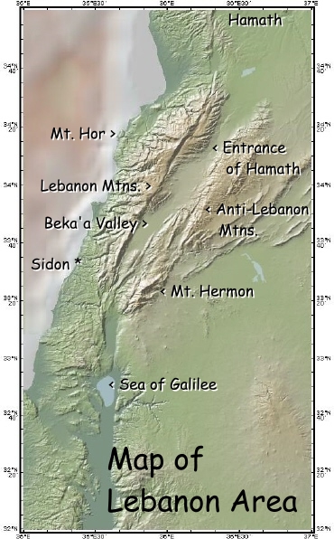
Geographic Border Locations:
Mount Hor
In the
Hebrew, this is written as "Hor ha-har" - literally, "Hor, the
Mountain" or "Mountain of the
mountain", perhaps meaning a prominent or significant mountain. The Bible refers to 2
different locations called Mount Hor. Most of the time it's refering to a mountain in the
south where Aaron died, near the border with the land of Edom. Another Mount Hor is on the
northwest corner of the Promised Land, and is the Mount Hor being discussed here.
The exact location is debated, but was on or near the Mediterranean coast.
Some have tried to identify it
with Qornet Es-Sawda (Black Horn), the highest peak in the mountains of Lebanon,
but there seems to be no historical evidence behind this. In various ancient
Jewish Talmudic and Midrashic writings this Mount Hor is identified as Amanah,
Amanim, Tur Amnon, Tavros Umanis, and Tavros Manis. As "Amanah",
it appears in the Bible in Song of Solomon 4:8. In the Greek era, it was
called Theouprosopon, "The Face of God". Today it is called Ras
al-Shakka, "The Cape of the Stone Hill". It's a promontory (a
headland, a prominent and high mass of land/rock jutting out into or standing
over a body of water - like The Rock of Gibraltar) on the coast of northern
Lebanon.
These are the only 2 references to this Mount Hor on the northern border:
Nm 34:7,8
7 “‘This shall be your north border: from the great sea you shall mark out
for you Mount Hor;
8 from Mount Hor you shall mark out to the entrance of Hamath; and the
goings out of the border shall be at Zedad;
Home Geographic Places Next Topic
Topographic map created at www.marine-geo.org
with labels added at BiblicalZionist.com